
One Man and his Dog.
Hawker Hurricane AG264 on Brim Fell.
(Distance covered =
5.4 mile/Ascent = +721m -719m)
Heather and her Mam had a weekend off from their Highland dancing competitions so had decided they would like to visit the South Lakeland Zoo, so for a change I had the opportunity to visit a crashsite in the Lake District. As I don't have a website called 'What to do while they visit south Lakeland Zoo' I have included it on this website.
South Lakeland Zoo is right down the bottom end of the Lake District and not far from the Coniston Fells ,so it was the perfect chance for me to revisit a couple of crashsites I went to way back in the 1980's/90's. One thing I remembered clearly from my earlier visits all those years ago was it was expensive to park in Coniston Village, I also remembered seeing cars parked in an old quarry much nearer to the fells, so I decided to park there, if I could find it. After driving up a couple of dead ends I eventually found a rather steep narrow road which looked like it was going in the right direction for the Quarry Carpark.
/BF1.JPG)
Blueberry Esmerelda Muffin II parked in the old quarry above Coniston Village.
These fells are very popular with Tourists and there was a lot of them out for a stroll today, most heading for the summit of 'The Old Man of Coniston', most dressed just in t-shirts and trainers. I suppose strictly speaking I was a tourist as well but I was on a mission and not just out for a stroll and I was suitably prepared in case the weather turned.
/BF2.JPG) There was a very nice Tourist Path which led right to the summit of The Old Man.
There was a very nice Tourist Path which led right to the summit of The Old Man.
On all my previous visits to the Coniston Fells I had always walked up the Coppermines Valley from Coniston, so it made a nice change approaching from this direction not least because I didn't have to pay anything to park and there was also some lovely footpaths to follow.
/BF4.JPG)
Further up the path leading to the Old Man of Coniston.
The path which comes up the Coppermines Valley to Levers Water can be see
over the other side of the Valley.
I didn't stay on the Tourist path for long but instead headed off on a less well used path towards Levers Water this nice path stopped being nice at some stone cairns where it became a muddy track more akin to what I'm used to.
/BF5.JPG)
Above and below:- Another nice path continued north towards Levers Water.
/BF6.JPG)
/BF7.JPG)
It stopped at these cairns but there was still a path of sorts to follow over to Levers Water.
On my way over from the stone cairns towards Levers Water I became aware of someone shouting very loudly at something, I couldn't see who it was but as I was nearly at Levers Water a sheepdog passed me at a rate of Knots followed by a shepherd who was bellowing instructions to the sheepdog, there was quite a few sheep dotted around the crags and it would seem they wern't co-operating in the slightest so the shepherd was perhaps becoming a little irate, because of this I had a sit down on a rock out of his way and waited until he'd passed.
/BF8.JPG) Levers
Water from the south and the location of one of the crashsites I hoped to
visit.
Levers
Water from the south and the location of one of the crashsites I hoped to
visit.
Once I reached Levers Water I had to decide wether to go around its shore on the right to go to the Anson crashsite first or, go around its left shore to visit the Hurricane crashsite on Brim Fell first. I chose the latter option.
/BF9.JPG)
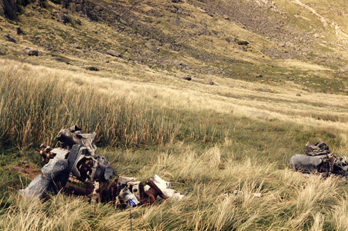
The location of the Hurricane crash(circled).The arrow points to the
location of the lumps of engine I found on my previous visit.
I didn't expect the big lumps of Rolls Royce Merlin I had found years ago
to still be there as they were full of pistons and valves and the thieving
magpies love to steal those to sell on ebay. Sadly I was right they were
gone!
Because I had found the remains of the engine in 1985 I didn't look further up the crags for the impact point, that was reason enough for my return visit so after a quick scout around to make sure the engine had been stolen and not just moved I started up the ever steepening crags below Brim Fell.
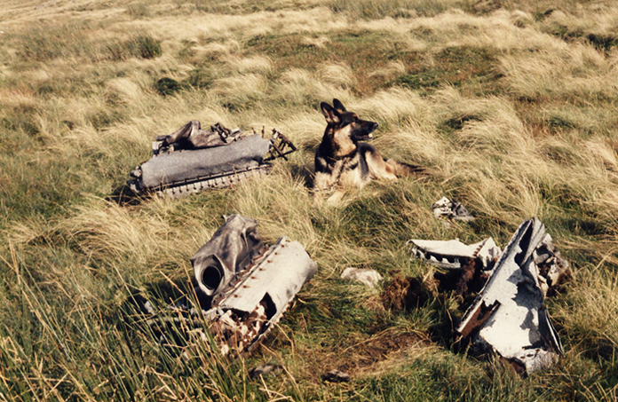
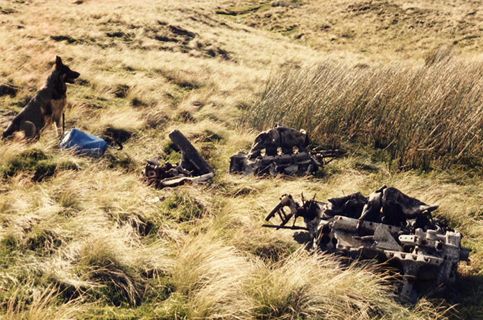
Above and next two photos:-The pieces of engine photographed with my trusty old Canon AV1 way back in 1985 when I visited with Kim my Alsation.
A grid reference isn't really much use in finding wreckage in amongst steep crags and gullies other than to put you in the right area, a gps device might help but I consider those to be cheating as I believe they remove all the sense of acheivement from navigating. Of course a gps would be handy if you found yourself lost but thats something I've avoided so far, I've gone the wrong way a few times but that's not the same as being lost. On the way up to the Hurricane wreck I came across a couple of Tourists near to Levers Water , they asked me which of the hills was The Old Man of Coniston as they'd been told to go up past Low Water, they didn't have a map or compass and had mistaken Levers Water for Low Water, they were lost!
/BF10.JPG) Looking back down to Levers Water on my way up Brim Fell.
Looking back down to Levers Water on my way up Brim Fell.
Just as I spotted the wreckage of AG264 high up on the crags below Brim Fell I heard a familiar voice yelling from above, it was the Shepherd again,his dog was running around just below where I was, it was frantically trying to round up some stubborn sheep which seemed intent on going in any direction but where the shepherd wanted them to go, I'm sure he must have been wondering what the idiot was doing on the steep crags below him, so I had a sit down again out of view and waited until he'd moved on.
/BF11.JPG)
The Hurricane crashed on the patch of scree at the bottom left of the photo
A couple of minutes after he'd moved on as I was taking some photos of the Hurricane
wreckage the Shepherd appeared on the next crag over, still yelling
instructions to his dog and a couple of minutes after that he appeared way down
below on the path from Levers Hause down to Levers Water, he couldn't half
cover the ground, he couldn't half yell as well!
The area where the Hurricane crashed is very steep and precipitous so I
didn't fancy going back down the way I'd come and also the angry Farmer was
still down
there and it sounded like he was berating some walkers who didn't have
their dog on its lead. My plan therefore was to climb up onto the top then follow
the path that runs around the ridge to above the Anson crash.
/BF22.JPG)
Looking over Levers Hause towards Swirl Howe and Great Carrs, location of a Halifax crash. The Anson crashed on the slopes to the right of Swirl Howe between the two peaks on the right of the photo.
By the time I reached the top of Brim Fell I decided I would be pushing it for time if I went over to the Anson crashsite, I'd lost a lot of time taking the two lost walkers back over to the Tourist path, then I'd had to sit and wait for a longtime to keep out of the way while one man and his dog tried their best to round up Shaun the Sheep and his awkward mates. So instead of turning right towards Levers Hause and Swirl Howe I turned left towards The Old Man of Coniston and the tourist path back down to the car.
/BF23.JPG)
Levers Water from the top of Brim Fell.
Walking across the top of Brim Fell I noticed two interesting things: 1-the grass on the top resembled someones front lawn. 2-Despite the Shepherds best efforts there were still two Sheep up here nonchalantly munching on said front lawn!
/BF25.JPG)
The Old Man of Coniston with the tourist path zigzagging down its flank
The summit of The Old Man and the path up from below was positively heaving with day trippers, I call them day trippers as none of them were suitably attired for climbing a Mountain even if the weather had been glorious all day.
/BF26.JPG) Low Water, nestled below The Old Man,
the southern tip of Levers Water can be seen middle distance.The photo
below was taken from the far end of Low Water looking back to the ridge
where I took this photo.
Low Water, nestled below The Old Man,
the southern tip of Levers Water can be seen middle distance.The photo
below was taken from the far end of Low Water looking back to the ridge
where I took this photo.
/BF27.JPG)
Two Hurricanes flying in formation crashed into these fells, AG264 which I'd just visited and
AG275 which crashed on these slopes above Low Water, I didn't look for
AG275 as I didn't have enough time or a grid ref to put me in the right
area.
I was making good progress to be back in time to pick the girls up from the Zoo but then I started getting distracted by all the old mine workings that litter the slopes of The Old Man, including an old winch shed with railway tracks and old winch machinery still in situ and an old abandoned Lorry, I'd love to know how that ended up where it is.
/BF28.JPG)
Above and next 5 photos:-Remains of the old mine workings and an old Lorry
/BF29.JPG)
/BF30.JPG)
/BF31.JPG)
/BF32.JPG)
/BF33.JPG)
After checking out the mine workings and the old truck I could still hear the Farmer across the other side of Coppermines valley, yelling at something, I don't know if it was his dog or some other walker copping it for not having their dog on a lead.
/BF34.JPG)
Nearly back down,The path on the left is the one over to Levers Water that I followed on the way out
I was a little late arriving back at the Zoo but to make ammends I took the girls to a nice little Hotel beside the River Leven at Newby Bridge for some tea. A lovely way to finish off a thoroughly enjoyable day.
/BF35.JPG)
Could put it on my 'nice place to have a picnic' list but technically it wasn't a picnic we had.
/BF24.JPG)